Scope
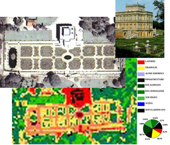
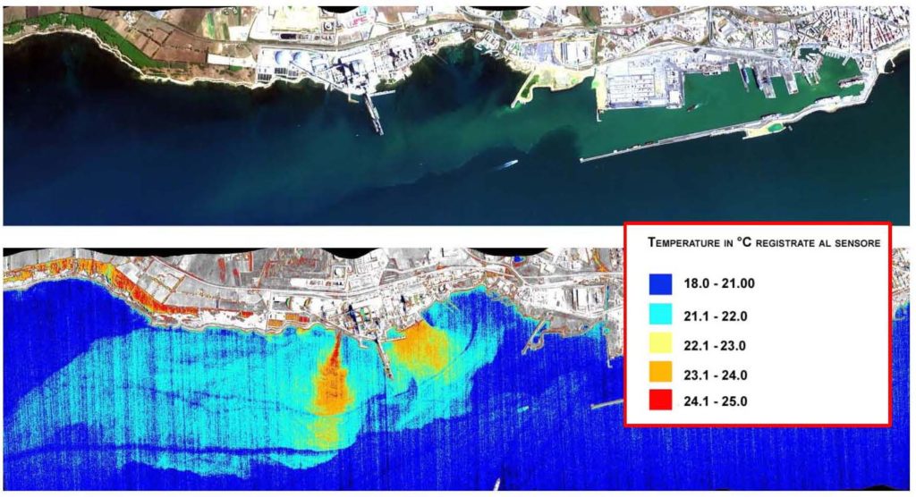
| This research aims to elaborate remote sensing data (hyperspectral and multispectral) to support knowledge, management and planning of the territory. Particular focus has been given to the study of the anthropized environment. The research group has expertise in the development of reproducible methodologies on a large scale. Such competences are used with use remote sensing, cartographic, ISTAT and environmental data in the geographic information systems and web environment. Together they aim to characterize and quantify the following: – historical-artistic artefacts and the environmental context in which they are located (Figure 1); – asbestos-cement (eternit) roofing (Figure 2); – land use for the study of changes (land use, or sprawl) ; – degraded areas (water pollution, landfills, etc.) through soil thermal analysis (Figure 3); – the resources of the environment and the landscape in their different territorial context, aimed at a sustainable development of the territory also for the purposes of use, enhancement and safety. Furthermore, the team can develop synthetic themes able to typify surfaces, and realize a thematic analysis of the territory at various scales. The group collaborates in research and service activities with the Lazio Region, ASL Rome 6, ENEA, INAIL, “La Sapienza” University (Rome), Tor Vergata University (Rome), ASI, etc. |
Selected projects
| AMINAVI (Data base) https://www.cnr.it/it/banche-dati-istituti/banca-dati/1069/aminavi In this last year (2017), the research group has designed and created a database called AMINAVI (http://www.aminavi.cnr.it/), which aims at discovering the presence of asbestos in Italian Military navy and Merchant navy. The creation of the database allows: – deepen and develop knowledge related to the presence of asbestos on board ships; – recover submerged and non-homogeneous data that represent historical memory; – to make paper data available (with no order in archives / deposits) that allow us to outline an overall view, to date never realized, with the ambition to create a network between the various bodies in charge of health and environmental protection, such as: INAIL , Ministry of Health, ReNaM, etc .; – optimize public resources. |
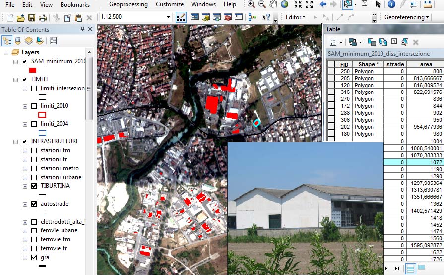
| Collaboration Agreement with ASL ROME6 for the Creation of a WebGIS The collaboration is aimed at providing technical and scientific support to the activities carried out by the Public Hygiene Service of ASL RM6, on the subject of asbestos. The INM research group has created a webgis based on Open Source technologies. This allows you to make asbestos risk analysis, starting from the values measured in the field. The Web environment applied to a geographic information systems, proved crucial for the development of a methodology and application reproducible on a large scale revolt to town and country planning, as able to integrate remote sensing data MIVIS with map data, statistical and environmental and provide spatial information with ease and interoperability for the ASL technicians. |
People
| Research Scientists and Engineers (Research team) Lorenza Fiumi, Dario Gallo, |
| Other Personnel (Research team) Carlo Meoni, Cinzia Crenca, |
Selected publications
2018 Fiumi L., Munafò M., Congedo L., Gallo D., Meoni C., Estimation of asbestos-cement roofing in the territory of the Lazio Region, | Italian Journal of Occupational and Environmental Hygiene, (IJOEHY), 2018, 9(1) ISSN 2464 – 8817, pp. 34-44.
2018 Fiumi L., Gallo D., Meoni C., L’amianto a bordo delle navi, Scienze e Ricerche, Magazine, n.50, ISSN: 2283-5873, pp. 9-17.
2017 Fiumi L., Munafò M., Congedo L., Gallo D., Meoni C., Stima della presenza di coperture in cemento-amianto nel territorio della Regione Lazio, Rapporto di ricerca CNR-INSEAN, ISBN 978-88-7617-041-6.
2017 Fiumi L., Gallo D., Meoni C., Il contributo della ricerca nella mappatura dell’amianto: le coperture in cemento-amianto, l’amianto a bordo delle navi, Geologia dell’ambiente, Supplemento n.4/2017, Rischio amianto in Italia: da minerale pregiato a minaccia per la salute e per l’ambiente periodico SIGEA, ISSN: 1591-5352 pp.39-45.
2017 Fiumi L., Meoni C., Alla ricerca dell’amianto con il telerilevamento, Sapere, anno 83 n.1 Febbraio 2017, Ed. Dedalo, ISBN 978-88-220-9423-0, pp. 28-33.
2016 Fiumi L., Presentazione del volume: la mappatura delle coperture in cemento-amianto. Un caso applicativo: La via Tiburtina. The Italian Association of Industrial Hygienists- AIDII Vol. 7 Issue 2, ISSN 2464-8817.
2016 Fiumi L., La mappatura delle coperture in cemento-amianto, ARPAT News, n.088- mercoledì 4 maggio 2016: http://www.arpat.toscana.it/notizie/arpatnews/2016/088-16/088-16-la-mappatura-delle-coperture-in-cemento-amianto
2016 Fiumi L., Ciarravano A., Meoni C., L’amianto nelle navi, Tecnologie Trasporti Mare maggio-giugno 2016. Vol XLVII n.3, Editore Itedi Spa, ISSN 1721-758X – ROC n. 18530.
2016 Fiumi L., Meoni C., Spinelli S., Di Francesco M., La mappatura delle coperture in cemento-amianto. Un caso applicativo: La via Tiburtina, Atti degli incontri di studio: Amianto e altri cancerogeni e patologie collegate, Firenze 15 aprile 2016, Cecina 16 aprile, 2016. Ed. Osservatorio Nazionale Amianto, ISBN 978-88-99182-13-7.
2015 Del Frate F., Fabrini I., Fiumi L., S. Tocci, Analysis of the soil sealing in the urban area of Rome through automatic processing of satellite data with neural networks, Applaied Geomatics Published on line april 2015 (DOI 10.1007/s12518-015-0157-0).
2015 Fiumi L., Tocci S, Meoni C., Hyperspectral discrimination of roofing materials in relation to history , International Journal of Remote Sensing & Geoscience (IJRSG), ISSN No: 2319-3484 Volume 4, Issue 3, May 2015, pp.44-52.
2015 Fiumi L., Tocci S, Meoni C., La mappatura delle coperture in cemento-amianto. Un caso applicativo: La via Tiburtina. Editore Consiglio Nazionale delle Ricerche, ISBN 978 88 8080 185 6.